^

Side Scan Sonar - 600 kHz

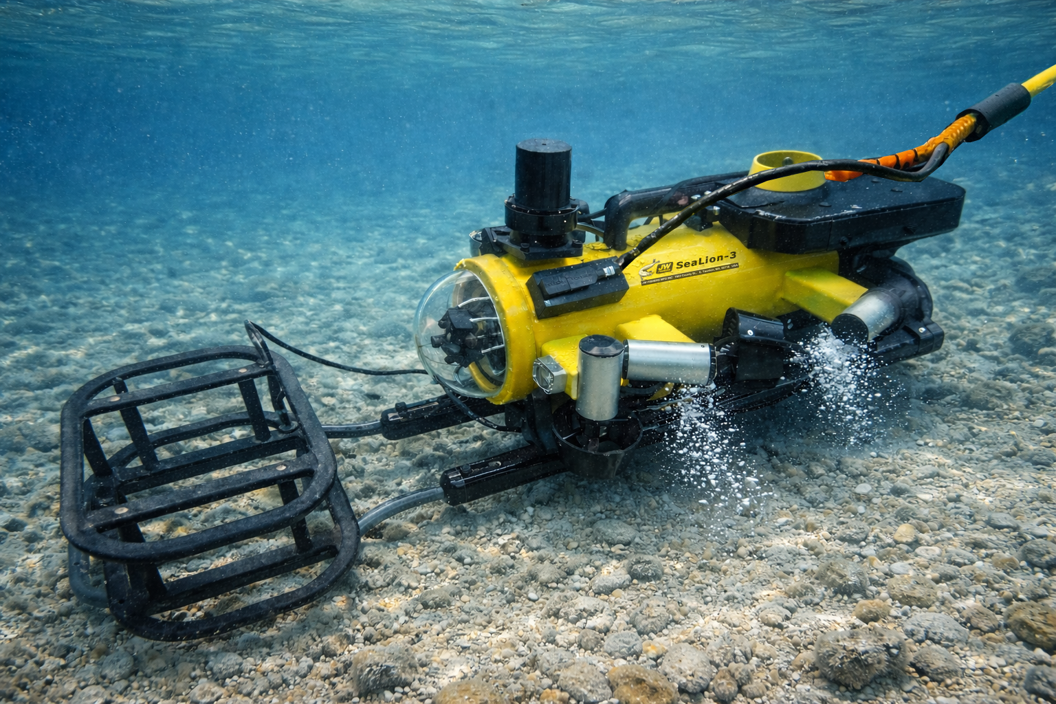
One of the most effective tools for underwater exploration

For more action shots, check out our Photos/Videos page

Side scan sonar is one of the most effective tools for underwater exploration because it can search a large area quickly and produce a detailed picture of anything on the bottom, regardless of water clarity. When looking at a side scan image it appears as if the water has been removed and the operator is getting an unobstructed view of the ocean floor, lake bottom, or river bed. High resolution images are sent from the towfish to a topside computer (included with the system) for display and storage. An optional Microsoft Surface® tablet mounted to the inside of the control box lid can be added for a “sleeker” package versus the standard laptop.

SONAR VIEW software gives the operator complete control over the system's operating parameters. Choose between 10 different scan ranges and 8 color schemes to display images. Connect a GPS and position coordinates are automatically captured with the side scan data. Point the mouse on a target and the GPS position coordinates for the target are displayed on the screen.

The SSS-600K side scan produces excellent resolution images when scanning with a 10 meter to 75-meter range setting. The 5-meter range produces good images, but lacks the sharpness of the higher ranges. The SSS-600K is great for law enforcement, dive rescue operations or any operation that requires a high-resolution image. Soft targets such as drowning victims, evidence recovery and bottom mapping are various capabilities. The 600K side scan is also popular with wreck hunters and archaeologists searching for old wood vessels that may be broken up or decomposing. The range settings in meters are: 5, 10, 25, 50, and 75 meters (each side).

Official Product Video

$24,995

ORDER NOW

More Details

Options

Articles

Fishers side scan sonar comes with a 500-foot depth rated towfish, 150 feet of cable (Kevlar reinforced), a laptop computer, a GPS, and Fishers SONAR VIEW software. The computer displays a real time color image of the ocean floor. The screen is split down the middle with the right side showing the ocean bottom on the right side of the vessel, and the left side of the screen shows the ocean bottom on the left side of the vessel.

The SONAR VIEW software gives the side scan operator complete control of all system functions with easy to use pull-down menus and icons on the screen. Size measurement tool, target height off bottom, annotation, and auto bottom tracking all standard. The operator can change colors, ranges, amplifier gain, and other controls with a click of the mouse. With the computer, side scan images can be stored in memory for playback and post processing at any time in the future. Small file sections including screenshots can be copied for emailing. With the GPS connected to the computer the position coordinates are captured with the side scan data. Once GPS is connected, the mouse cursor can be placed on any object on the screen and its position coordinates will be displayed. Sonar files can be stored on the computer's hard drive or an external memory component.

An optional Sonar Coverage Mapping feature shows the boat's path as it travels over the search area and the sonar coverage swath. It's all displayed on a grid with latitude and longitude as the X and Y axis. This option makes it easy to search even large areas and ensures no part of the area is missed. The map can be shown in a separate window on the same screen as the side scan image, or the map can be displayed on a separate monitor. The user can also control the size of the map. The map can be exported as an image with a KML file to allow it to be easily overlaid on other mapping programs (as shown at the right). All data can be stored on the PC hard-drive or USB component

A Microsoft Surface® tablet (optional) can be ordered with the Side Scan system. The tablet is mounted inside the control box lid for a “sleeker” package.

An optional GETAC S410 Semi-Rugged Laptop available for small, open boat operations. Raising the bar on the semi-rugged notebook class, the new S410 is MIL-STD-810G certified, more rugged, slimmer and lighter than ever before. The all-new S410 boasts the latest computing innovations, including a significant CPU performance boost, massive graphics enhancements, and a multitude of game-changing capabilities and options. The S410 puts unmatched power and adaptability into the hands of professionals in field service, manufacturing, public safety sectors.

Portability, rugged construction, low cost, and ease of operation. Four models to choose from. Larger towfish ensures stability and provides high quality sonar images. Dual frequency has both high and low frequency transducers in one towfish. Computer and software included with the system. Fishers SONAR VIEW software provides the user with lots of flexibility in displaying and manipulating sonar images.

Each side scan system is backed by Fishers exclusive, unconditional TWO YEAR warranty.

  • Extra Cable: $6.50 per ft
  • CMS-1 Cable Management system (cable reel up to 500'): $2,995
  • CMS-2 Cable Management system (cable reel up to 1,000'): $3,495
  • Underwater Cable Connector: $895
  • Adjustable Transducers: $995
  • Tablet 10.8" Windows® based tablet mounted into control box: $949
  • GETAC® Laptop - S410 (or equivalent) semi-rugged 14" laptop, MIL-STD 810H certified: $1,995
  • Sonar Coverage Mapping software: $1,995
  • DDW-1 Deep Dive Wing: $1,395